Guilford County · North Carolina

Find Guilford County septic records online

Send the property. We’ll trace the permit, layout, approval, or repair file—and explain what the official response actually means.

  • Accurate requests
  • Real records
  • Plain-English findings
The county answer

At a glance.

Who holds the file
Guilford County On-Site Water Protection office is the working official route for this property record.
What to request
The complete file—including the permit, approvals, site plan, final inspection, and related documents.
If nothing appears
An empty search is not proof that no file exists. Confirm it with the office before making a property decision.
Official route workspace

Start with the right county path.

Find the permit, layout, approval, or repair trail without guessing which office owns it.

Route details Responsibility, limits, and completion
Start here

Start in the county GIS Data Viewer with the address or REID. Check the property's linked well and septic documents and Water Quality layers, then request the missing permit or layout through the county records portal. On-Site Water Protection also answers system-location questions at 336-641-7613 between 8 a.m. and 10 a.m. when an updated file exists.

Current route: Open Guilford County GIS Data Viewer · reviewed 2026-10-05

Local route note

Start in the county GIS Data Viewer with the address or REID. Check the property's linked well and septic documents and Water Quality layers, then request the missing permit or layout through the county records portal. On-Site Water Protection also answers system-location questions at 336-641-7613 between 8 a.m. and 10 a.m. when an updated file exists.

What this route can do Search with official fallback
Official access Search with official fallback
SepticPath can Search first, request if missing: property clues and route
You complete Check the GIS parcel and linked documents first. If the septic file is missing or incomplete, complete a focused NextRequest request; phone help remains available for system-location questions.
Done means A documented system-location answer, property file, request reference, or written no-record response

County-specific workflow. The route and handoff below were reviewed for this county. The government site or office still controls the final search, signature, payment, and submission. Route reviewed 2026-10-05.

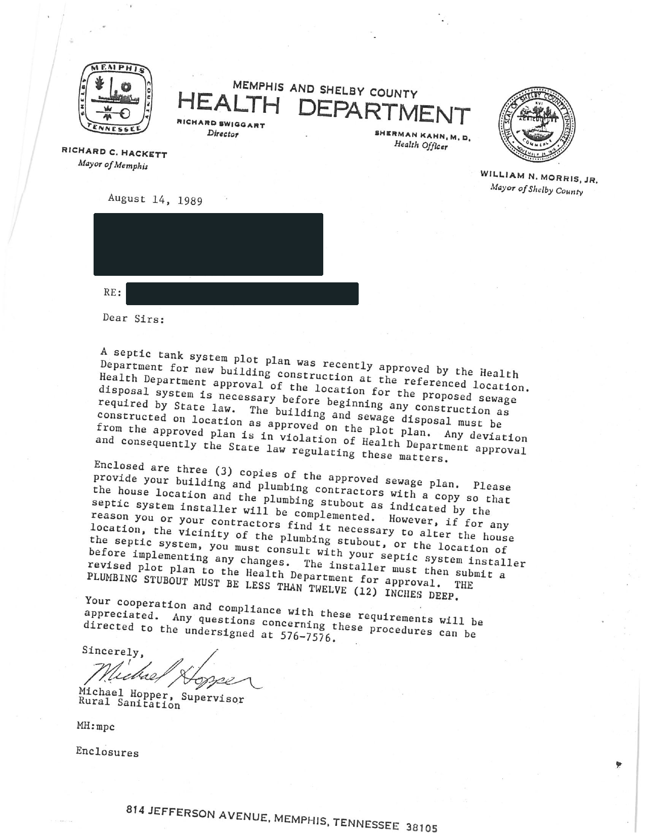
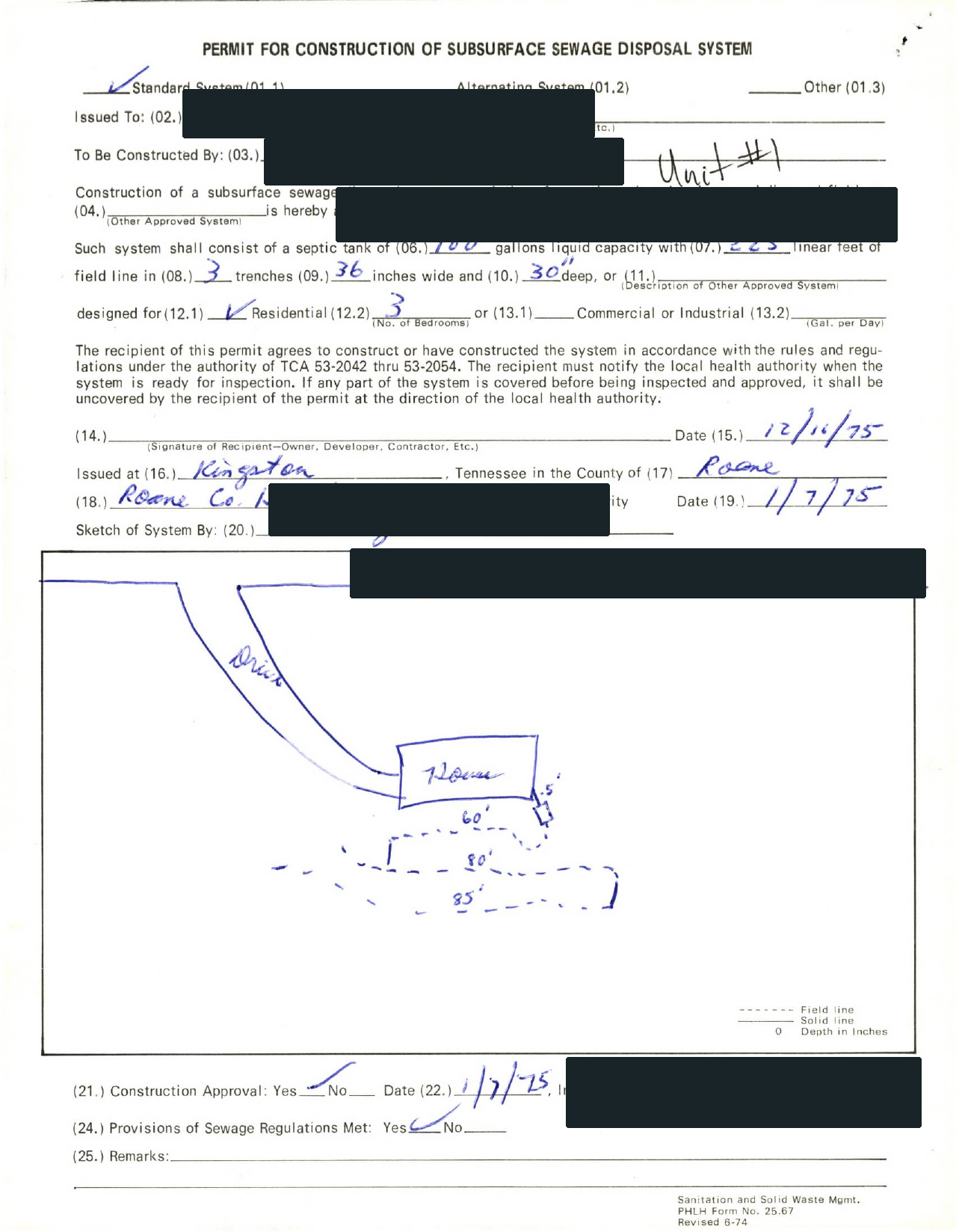
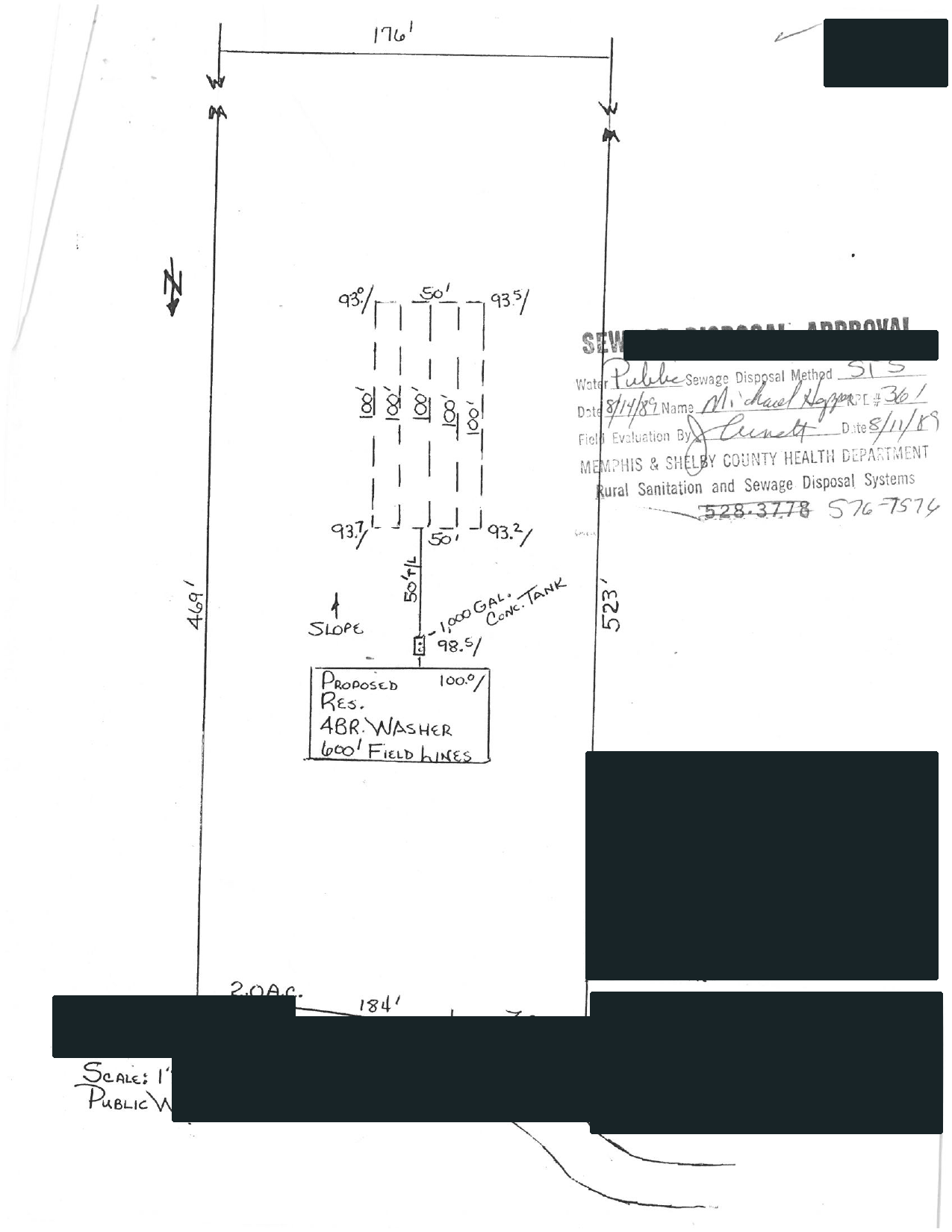
REAL COUNTY FILES

This is the kind of record the route should produce.

Selected pages from completed requests show the original agency file, drawing, and plain-English brief. Availability still depends on the property and office.

01 / RECEIVED FROM THE COUNTY

Swipe to compare the original pages Document 1 of 3

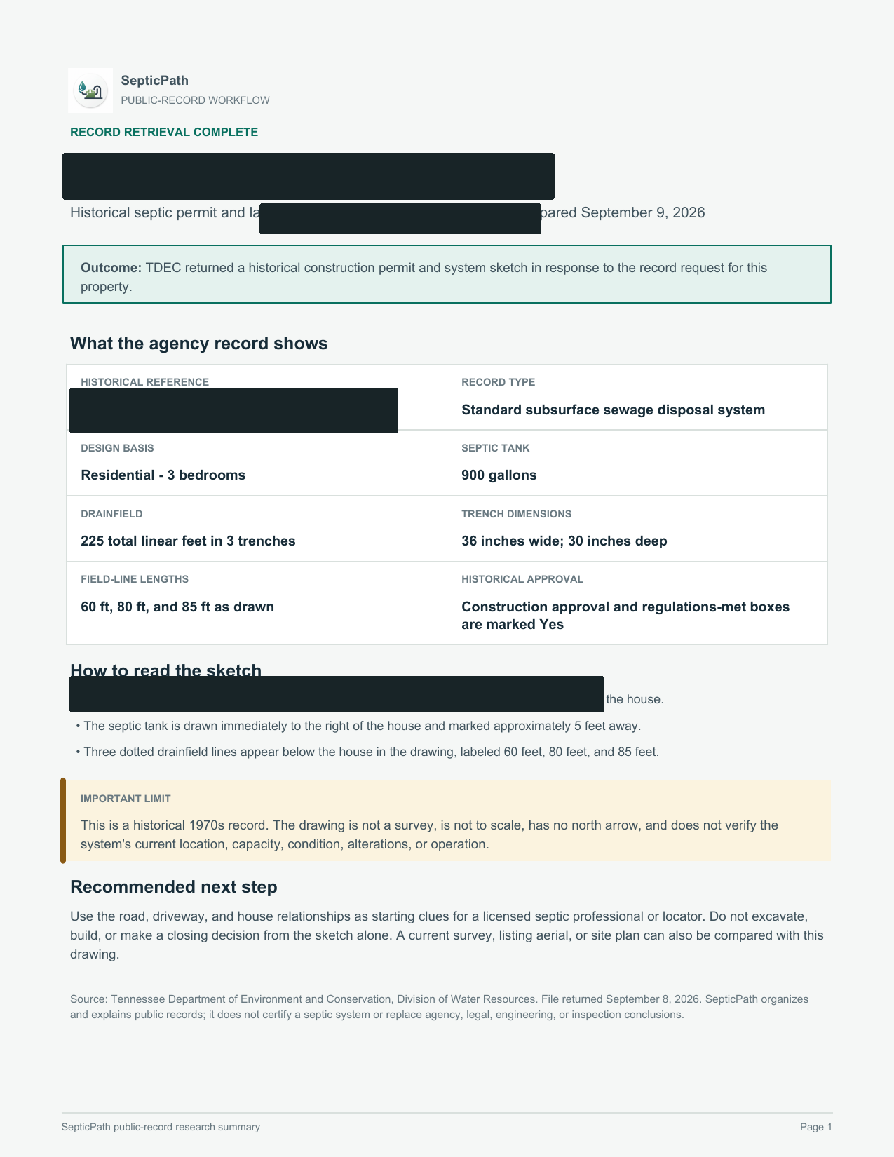
02 / EXPLAINED BY SEPTICPATH
SepticPathRECORD BRIEF
Nearly full page of a SepticPath Record Brief with the property identifiers redacted

What this helps withA starting point for discussing the layout with a septic professional.

What it does not proveThis is an approved design, not proof of the system’s current location or condition.

Open the delivered brief ↗

Privacy reviewed: black bars remove identifying details; agency language, form structure, system data, and drawing geometry remain visible. Samples are from separate requests, not one property file. Record availability varies by property and jurisdiction.

  1. Search public sources
  2. Request agency files when needed
  3. Explain what comes back
Investigate my property Send the address and what you need to find out.
Document excerpt

Actual county record retrieval · Identifying details removed

Search stuck? Get free record help → Or, if the next step is on site, request local service help.

Verification and local notes Reviewed 2026-10-05
Why we trust this route
Access type GIS property files with records-request fallback
Completion A documented system-location answer, property file, request reference, or written no-record response
First file to pull The improvement permit, construction authorization, operation permit, septic layout, or existing-system authorization.
Sources checked 5 official sources 2026-10-05

Start in the county GIS Data Viewer with the address or REID. Check the property's linked well and septic documents and Water Quality layers, then request the missing permit or layout through the county records portal. On-Site Water Protection also answers system-location questions at 336-641-7613 between 8 a.m. and 10 a.m. when an updated file exists. Completion means A documented system-location answer, property file, request reference, or written no-record response.

Local signal: Search Guilford County GIS by address or REID for well and septic records, layout clues, and the next request route when the file is incomplete.

Record route
File owner
Guilford County On-Site Water Protection office
Access
GIS property files with records-request fallback
Done when
A documented system-location answer, property file, request reference, or written no-record response
Watch for
A well-only PDF or missing septic map feature is not an official no-record response. Match the property identifiers and check earlier parcels when relevant. GIS is not survey-grade; historical drawings do not locate the system on the ground. NextRequest may require verification and final submission.
How this route was checked
Maintained by
SepticPath content team Product-maintained guidance
Source review
SepticPath official-source checks Official-link and workflow review
Reviewed against
Cites 5 official county or state sources. The date below is the latest page or source review activity.
Latest review
2026-10-05

This Guilford County, North Carolina route is maintained as conservative homeowner guidance and changes when its official file path changes.

Property record task

Search the official county system

GIS property files with records-request fallback
Property facts to carry Keep the address and parcel clue ready without pretending these are county form fields

Match the GIS parcel by address or REID, review its linked well and septic documents and Water Quality layers, then use NextRequest for the specific missing file. Call 336-641-7613 between 8 a.m. and 10 a.m. for system-location help when an updated file exists. These are routing facts for your own handoff, not claimed county submission fields.

Routing facts to confirm

Use these to identify the responsible office before asking for the file.

Next official action Finish on the official route

Match the GIS parcel by address or REID, review its linked well and septic documents and Water Quality layers, then use NextRequest for the specific missing file. Call 336-641-7613 between 8 a.m. and 10 a.m. for system-location help when an updated file exists.

Your final manual step Review the prepared details, complete any county-only login, signature, CAPTCHA, or payment-consent step that appears, then submit in your own name. SepticPath does not sign in, accept charges, sign, or press the county's final submit button for you.
Preparation aid — not an official county form Official search carry sheet

Download or print the values above. The government page remains the official route.

Show the county-specific steps
  1. Open the GIS Data Viewer, find the exact address or REID, and confirm the parcel and PIN.
  2. Check linked well and septic documents and the Water Quality layers for tank, trench, layout, and permit-grid clues. Read the linked file rather than relying on a map marker.
  3. If the file is well-only, incomplete, or missing, carry the current and any earlier parcel identifiers into a focused NextRequest request for the underlying septic file.
  4. Retain the county's written response. For system-location questions, the published phone route is 336-641-7613, 8-10 a.m.

Route details Fees, timing, and responsibility
File owner
Guilford County On-Site Water Protection
Fee
The county says some services have fees but does not publish a historical phone-lookup or record-copy fee on the reviewed page.
Timing
Call between 8 a.m. and 10 a.m.; no records-portal turnaround is published.
You still do
Check the GIS parcel and linked documents first. If the septic file is missing or incomplete, complete a focused NextRequest request; phone help remains available for system-location questions.
Field verification
Official route confirmed; exact submission fields are not published or independently verified
SepticPath prepares We preserve the property facts, show the current official route, published cost and timing, and flag any office or jurisdiction decision that still needs confirmation.
You finish at the county Check the GIS parcel and linked documents first. If the septic file is missing or incomplete, complete a focused NextRequest request; phone help remains available for system-location questions.
Task scope to review This is your saved job scope, not county-authored request wording.
  • system type and location information
  • improvement permit and construction authorization
  • operation permit and layout
  • repair, monitoring, or abandonment records
Need the supporting research? Open official evidence, local exceptions, FAQs, and related routes
Verified local evidence

What the official sources actually document for Guilford County

These source notes replace repeated county-template copy. They describe the real lookup, permit, map, inspection, or request path found in the cited government material.

  1. County-scoped source

    GIS Online Services and Primary Data Viewer

    Official directory links the GIS Data Viewer and parcel research. Viewer opened interactively; GIS disclaimer and search controls reviewed. No customer property or file published.

    Guilford County
  2. County-scoped source

    Public Records Request

    Official public-records portal linked from the current county On-site Wastewater page for file-copy requests after the phone lookup.

    Guilford County
  3. County-scoped source

    Water Quality Well and Septic Layers

    Official service lists soil evaluation, well inspection, septic tank, trench, layout, area, unsuitable area and permit-grid layers. A layer or missing feature is not a complete property-file conclusion.

    Guilford County GIS
  4. County-scoped source

    On-site Wastewater

    County onsite wastewater page covering site evaluations permits inspections repairs monitoring and abandonment and publishing a system-location phone lookup at 336-641-7613 from 8 to 10 a.m. when an updated property file exists.

    Guilford County Public Health
County evidence File details, access method, and source checks Open only when you need the full local evidence behind the official route above.
Priority county route

Guilford County records and permit guide

For the Guilford County search path: Use this county route to find the office, official lookup, first file, and fallback needed for septic records, permit questions, inspections, or a parcel-specific request.

Official records route How do I find guilford county septic records? How do I find guilford county septic permit lookup? How do I find guilford county septic system location? How do I find Guilford County NC septic permit lookup? How do I find Guilford County septic records request?
Start here

For guilford county septic records, start with the county office, official route, and first artifact before opening a broad state guide.

First artifact

The improvement permit, construction authorization, operation permit, septic layout, or existing-system authorization.

Request method

Records request or email. The page should make the official record path, request wording, and fallback office visible without another search.

When the lookup stalls

Lead with the county record path and ask for the parcel identifier, permit copy, as-built, final approval, inspection letter, or written no-record response.

Official county file path

Use this Guilford County file path before another broad search.

Guilford County uses this table as a work surface: identify the file owner, carry the right property clue, request the first useful artifact, and preserve a written fallback when the lookup has no result.

File owner First artifact Request method No-record fallback
File owner

Guilford County On-Site Water Protection office. Verify whether this office owns the full septic file or only the first handoff before treating the result as complete.

Lookup clue

For Guilford County, carry the street address, parcel ID, owner name, legal description, subdivision, or prior permit clue into the county records route.

First artifact

The improvement permit, construction authorization, operation permit, septic layout, or existing-system authorization.

Request method

Records request or email: Open Guilford County GIS Data Viewer, ask for The improvement permit, construction authorization, operation permit, septic layout, or existing-system authorization., and keep the state route nearby if the county sends part of the file to a regional or delegated office.

No-record fallback

If the Guilford County search returns no match, ask Guilford County On-Site Water Protection office for a written no-record response and the next owning office before assuming the property has no septic history.

State handoff

If the county route stalls, move back to the North Carolina records page with the same parcel clues instead of restarting with a broad web search.

County record availability matrix

Guilford County file path, request method, and expected evidence

Availability describes the documented official route. It does not predict whether a property-specific file exists.

Documented access type GIS property files with records-request fallback
Primary route Open Guilford County GIS Data Viewer
Request method Records request or email
First artifact The improvement permit, construction authorization, operation permit, septic layout, or existing-system authorization.
Evidence depth 5 official sources
Parcel or property anchor Verify through records office
Method County records fallback

Use the Guilford County records path and ask which address, owner, APN, TMS, or legal description field Guilford County On-Site Water Protection office needs.

Open Guilford County GIS Data Viewer
Permit copy or approval file County-specific signal found
Method Search or portal

Guilford County evidence: The file is stronger when it includes a final approval, operation approval, license to operate, diagram, or other closeout artifact rather than only an application.

Open Guilford County GIS Data Viewer
As-built, site plan, or layout Layout signal found
Method Record request

Ask whether the Guilford County file includes the installed layout, site sketch, tank location, drain field location, or approval package tied to the parcel.

Open Guilford County GIS Data Viewer
Inspection letter or transfer artifact Buyer artifact likely relevant
Method Transfer check

Guilford County: This county has a buyer-side artifact that matters more than a generic permit copy. Pull the transfer or status document before you treat the sale as routine.

Open buyer workflow
Repair, malfunction, or modification trail Repair trail flagged
Method Risk gate

Guilford County: The county repair branch matters here. Pull the repair or failure-side file before assuming the cheapest visible scope is still available.

Open Guilford County GIS Data Viewer
County detail Workflow structure, requests, and low-end breakers Open when you need the full county file logic behind the answer panel.

Why Guilford County is worth its own page

Guilford combines parcel-based GIS document clues with Water Quality map layers and a public-records fallback. Separating a map match, a well file, and an actual septic record helps you ask the right next question.

Use this route for a Guilford County parcel when Guilford County GIS is the documented source for the next records decision. Official service lists soil evaluation, well inspection, septic tank, trench, layout, area, unsuitable area and permit-grid layers. A layer or missing feature is not a complete property-file conclusion.

County workflow structure

File owner model

Guilford County is the practical file owner for county-level searchers; the state guide helps only after the county record path is clear.

First artifact to pull

Guilford County evidence: the improvement permit, construction authorization, operation permit, septic layout, or existing-system authorization

Permit closeout signal

Guilford County evidence: The file is stronger when it includes a final approval, operation approval, license to operate, diagram, or other closeout artifact rather than only an application.

Transfer or buyer artifact

Guilford County evidence: improvement permit, construction authorization, and operation permit records plus any sale, inspection, or existing-system document the county can attach to the parcel.

Special program or local exception

Guilford County may add local forms, portals, fees, or office routing on top of the state baseline.

Malfunction or repair trail

Guilford County evidence: Any complaint, failure, repair application, or tank replacement record should be resolved before the system is treated as routine.

Do not price yet when

Final Guilford County workflow gate: Guilford County evidence: Do not move from lookup to pricing until the county file owner, first artifact, and repair or closeout status agree with the buyer, seller, or contractor story.

How this county workflow usually unfolds

  1. Search the official GIS Data Viewer by address or REID. Confirm the parcel and PIN, then check linked well and septic documents and Water Quality layers.
  2. Cross-check Public Records Request from Guilford County. The verified source note for this route is: Official public-records portal linked from the current county On-site Wastewater page for file-copy requests after the phone lookup.
  3. Resolve the handoff through Water Quality Well and Septic Layers from Guilford County GIS. The verified source note for this route is: Official service lists soil evaluation, well inspection, septic tank, trench, layout, area, unsuitable area and permit-grid layers. A layer or missing feature is not a complete property-file conclusion.

What to ask the county for

  • First Guilford County file item to match against Guilford County: the improvement permit, construction authorization, operation permit, septic layout, or existing-system authorization
  • Transfer item to verify through Guilford County: improvement permit, construction authorization, and operation permit records plus any sale, inspection, or existing-system document the county can attach to the parcel
  • The file, form, map, or approval described by Water Quality Well and Septic Layers: Official service lists soil evaluation, well inspection, septic tank, trench, layout, area, unsuitable area and permit-grid layers. A layer or missing feature is not a complete property-file conclusion.

What breaks the low-end story

  • Do not treat the low end as resolved while the records route in GIS Online Services and Primary Data Viewer is still open. Official directory links the GIS Data Viewer and parcel research. Viewer opened interactively; GIS disclaimer and search controls reviewed. No customer property or file published.
  • Do not treat the low end as resolved while the parcel evidence in Public Records Request is still open. Official public-records portal linked from the current county On-site Wastewater page for file-copy requests after the phone lookup.
  • Do not treat the low end as resolved while the office handoff in Water Quality Well and Septic Layers is still open. Official service lists soil evaluation, well inspection, septic tank, trench, layout, area, unsuitable area and permit-grid layers. A layer or missing feature is not a complete property-file conclusion.
Source layer FAQs and official county sources Open when you need the source list or county-specific FAQ answers.

How do I look up septic records in Guilford County?

Start in the official GIS Data Viewer with the address or REID. Confirm the parcel and PIN, review linked well and septic documents, and check Water Quality layers for tank, trench, and layout clues. If the septic file is absent or incomplete, request the missing records through the county's NextRequest portal using current and earlier parcel identifiers when relevant.

What should I ask for before trusting a septic quote in Guilford County?

Ask for improvement permit, construction authorization, and operation permit records, plus any repair, final inspection, as-built, approval, or complaint history. That file tells you whether the next move is normal pricing, a repair branch, or a more cautious permit check.

Official county sources
  • Guilford County Public Health On-site Wastewater
    Trust: high Content reviewed: 2026-07-29 HTTP reachable: 2026-07-29 Method: manual browser review
  • Guilford County Public Records Request
    Trust: high Content reviewed: 2026-07-29 Automated check blocked: 2026-07-29 Method: manual browser review
  • Guilford County GIS Online Services and Primary Data Viewer
    Trust: high Content reviewed: 2026-10-05 HTTP reachable: 2026-10-05 Method: official page and browser review
  • Guilford County GIS Water Quality Well and Septic Layers
    Trust: high Content reviewed: 2026-10-05 HTTP reachable: 2026-10-05 Method: official page review
  • North Carolina Department of Health and Human Services 18E Resources
    Trust: high Content reviewed: 2026-03-09 Automated check inconclusive: 2026-07-21 Method: legacy editorial review Manual reachability review queued

Related North Carolina pages

Other strong North Carolina county routes